Episode 3: The Kingdom of Louis Dix-Huit
This is The Siècle, Episode 3: The Kingdom of Louis Dix-Huit.
The kingdom that Louis XVIII ruled after the dust settled on the Hundred Days was not quite the same one he had ruled before Napoleon’s escape from Elba. The vengeful Allied powers that had beaten Napoleon stripped away several chunks of territory along France’s northern border, and gave another chunk in the east to Switzerland. All told France lost around 2,000 square miles, or 5,200 square kilometers, of land — about the size of Delaware. This was fairly densely populated land, too, with around 300,000 residents.1 (Delaware at the time had fewer than 75,000 inhabitants.)
The final borders set in 1815 largely resemble France’s boundaries today, with two exceptions in the southeastern part of the country that were added to France in 1860. We’ll talk about that in due course on The Siècle.
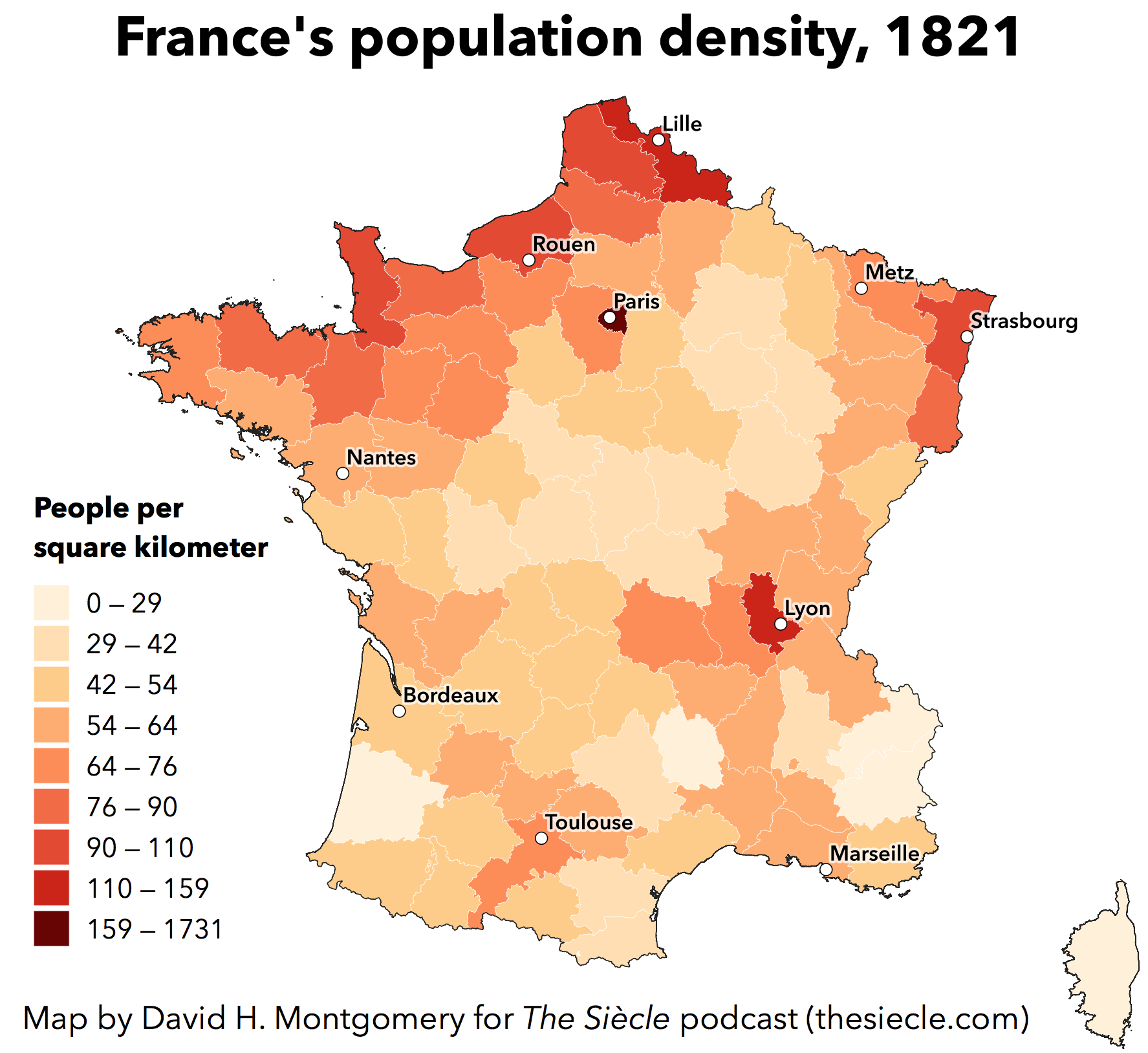
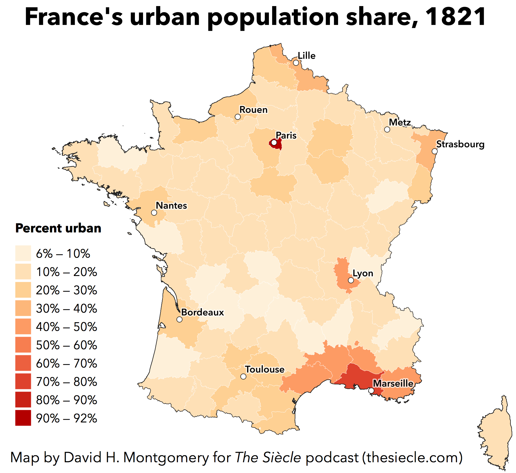
For now, the European portion of Louis’s kingdom was about 206,000 square miles, or about 533,000 square kilometers, and had around 30 million people, for an average density of 145 people per square mile, or 56 people per square kilometer.2 That average is misleading, given that some major areas, like the island of Corsica or the Lozère department in central France, had as few as 10 people per square mile or four per square kilometer. Paris, in contrast, squeezed more than 700,000 people into just 13 square miles, or 34 square kilometers — more than 50,000 people per square mile or 20,000 per square kilometer, not far below the modern-day population density of Paris.3 Louis’s France was divided into 86 départements or departments, one of the many legacies of the Revolution that Louis would accept during the Restoration.

Those 86 departments include major cities and tiny villages, sprawling fields and desolate mountain ranges, shining castles and tiny hovels. There are areas that are rich and fertile, and those that are so poor and disease-ridden that sneering city-dwellers will call their residents barely human. For a country a little bit smaller than Texas, France has incredible variation — and this was even more pronounced in 1815, when communication was poor and literacy rare.
So before we delve too much deeper into this century, I’m going to take you on a tour of France in 1815. I’ll lay out the country’s physical geography, then walk you through its major regions.
If you’re able, I’ll encourage you to follow along with this episode online, at thesiecle.com/episode3 — that’s t-h-e-s-i-e-c-l-e dot com slash episode3, with three as a numeral. There I’ve posted a number of maps I made to illustrate my descriptions in this episode. If you can’t follow along now, take a look when you’re able. Podcasts are an amazing medium, but sometimes there’s just no substitute for a good map.
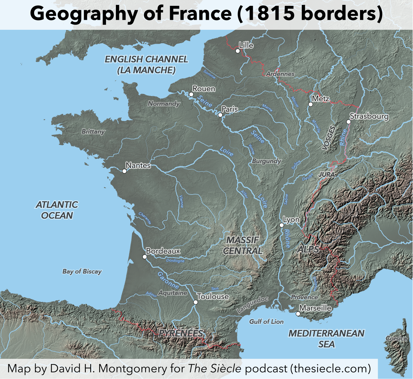
Let’s start out with a bird’s-eye view of the country. France is bordered by the Atlantic Ocean to the west, the Mediterranean Sea to the southeast, and the English Channel — or la Manche — to the northwest. Its southwestern border with Spain follows the Pyrenées mountains, while the Alps and Jura mountain ranges guard its eastern borders with Switzerland and what is today Italy but was then the Kingdom of Piedmont-Sardinia. Further north, the Rhine river runs between France and the German Confederation. All these borders follow natural landmarks and are fairly defensible.

“Europe 1815. Political situation after the Congress of Vienna in June 1815,” by Alexander Altenhof. CC BY-SA 4.0, via Wikimedia Commons.
That leaves France’s northeastern border, by far the most geopolitically important. This is the only French border that doesn’t follow a natural boundary as it cuts from the Rhine to the English Channel. In 1815, the Kingdom of the Netherlands sat on the other side of this border in the west, occupying what is today Belgium. Going further east was the Grand Duchy of Luxembourg, and German territory ruled by the kingdoms of Prussia and Bavaria. These borders were the result of peace treaties at the end of the Napoleonic Wars, which gave Belgium to the Netherlands and Rhineland territory to Prussia and Bavaria in an attempt to constrain France. Before the Revolution, France had bordered a patchwork collection of minor German states here.4
Let’s talk about the interior. The best way to think about it is that France’s interior is defined by three areas of highlands, two big basins, and two river valleys.

Map from Geography of France by Raoul Blanchard & Millicent Todd, 19. Public domain.
First, let’s take the highlands. The simplest one to describe is what geologists call the Armorican Massif. That’s an area of rough terrain that roughly corresponds to the northwestern peninsulas jutting into the Atlantic Ocean and English Channel. The highest points here are only about 1,300 feet, or about 400 meters above sea level, which isn’t very high. That’s because the mountains that rose here hundreds of millions of years ago have largely eroded away. But despite the low peaks this area has rugged terrain and, at the time, notably infertile soil — characteristics that made it difficult to conquer and control.5
The second highland area, and the biggest, occupies a vast stretch of more than 30,000 square miles or 77,000 square kilometers — about the size of the state of South Carolina — in south-central France. This is the Massif Central, a mixture of mountains, plateaus and valleys whose elevation ranges between 1,000 and 6,000 feet above sea level, or 300 to 1,800 meters.6
Finally, the Vosges Mountains are a low mountain range in northeastern France, just west of the Rhine and the border with Germany. Its rounded summits stretch between 4,000 and 5,000 feet above sea level, or 1,200 to 1,500 meters.
To the east of the Vosges is the Rhine Valley, a fertile stretch whose French portion is about 100 miles or 160 kilometers long from north to south, and less than 20 miles or 32 kilometers wide between the river and the Vosges. Strasbourg is the most famous city in the Rhine Valley.
South of the Rhine Valley, in between the Massif Central and the Alps is another river valley, that of the Rhône and Saône rivers. This is a north-south valley running for hundreds of miles between the Vosges and the Mediterranean, which lets travelers and trade bypass the mountains to either side. Because of this, it’s vitally important for understanding France — the Rhône-Saône Valley is how people and goods get between Paris, Italy, and the entire Mediterranean.
These similar-sounding names can get a little confusing, so just to hopefully clear things up a little: the Rhine flows northward, between France and Germany, and enters the North Sea in the Netherlands, while the Rhône flows southward, through France, and enters the Mediterranean near Marseille. The Saône is a smaller river that starts in the Vosges foothills and flows south until it joins the Rhône, flowing down from the Swiss Alps to the east, at Lyon. All clear? Probably not. Again, visit thesiecle.com/episode3 to follow along with maps.
This leaves France’s two great lowland basins, full of towns and fields. The first dominates southwestern France and is called the Aquitaine Basin. It’s drained by the Garonne River. This is the region of Bordeaux, located where the Garonne meets the Atlantic, and Toulouse, a prominent city more than 100 miles or 160 kilometers upstream.
Finally, the north of France is largely composed of the Paris Basin, a vast mixture of valleys and plateaus encompassing Paris, the Seine River, and part of the Loire River. Besides Paris, other cities in this flat, fertile area include Orléans — the namesake for New Orleans — Reims, and Rouen. The Paris Basin is home to the famous culinary regions of Champagne and Brie, among many, many others. On the east, the region of Burgundy lies between the Paris Basin and the Rhine and Saône river valleys.
You can see maps of this basic geography at thesiecle.com/episode3.
Everyone caught up? To refresh briefly with reference to modern countries: France has ocean to the west, the Pyrenees Mountains on its southern border with Spain, the Alps on its southeastern border with Italy, the Jura Mountains on its eastern border with Switzerland, the Rhine River on its northeastern border with Germany, and relatively open terrain on its northern border with Germany, Luxembourg and Belgium. Its northern stretches are dominated by the vast Paris Basin, while the southwest contains the Basin of Aquitaine. The south-central part of the country contains the vast highlands of the Massif Central, which are separated from the Alps by the north-south river valley of the Rhône and Saône rivers. Finally, the Vosges Mountains in northeast France separate the Rhine Valley from the rest of France.
Alright. Let’s take a deep breath, and go deeper. After that bird’s eye view to orient you, I’m going to take you on a sort of brief walking tour of France as it existed under Louis XVIII.
Northeastern France
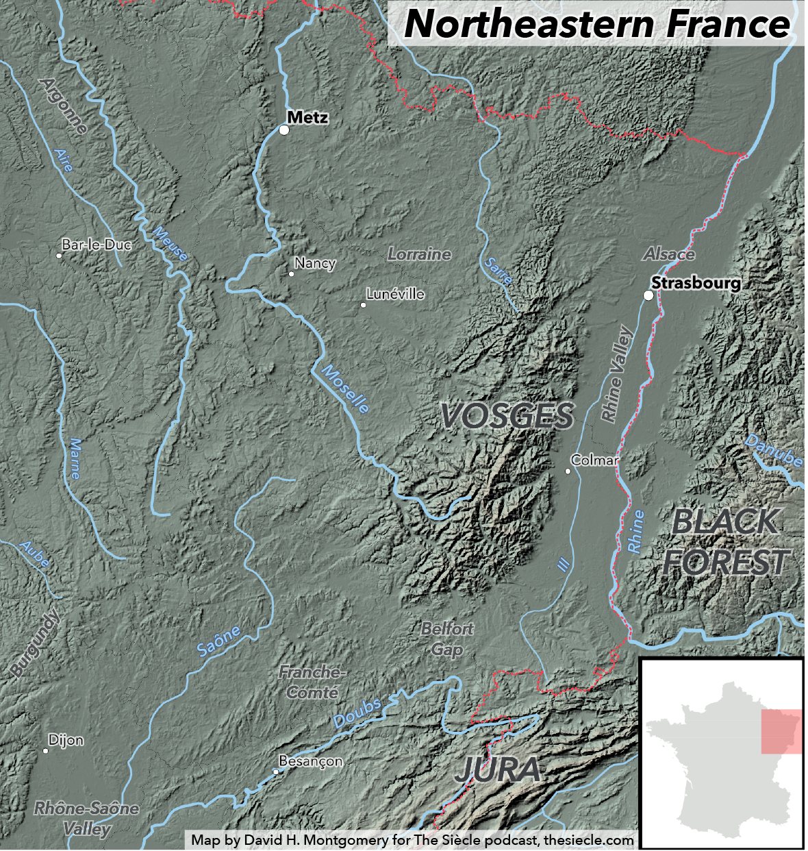
We’ll start in the Rhine Valley in the northeast. This is the area of Alsace and Lorraine, which France will lose to the new state of Germany in 1871, then reclaim after World War I. And, in fact, most of the inhabitants of this region spoke little or no French, only Germanic dialects such as Alsatian, though its various parts had been part of France for 50 to 100 years by 1815. This area was thickly populated for 1815 France, with population densities as high as 280 people per square mile, or 108 per square kilometer. This density was affected by both a high birth rate and also an unusually high vaccination rate that kept the death rate down.7
Alsace and Lorraine also had more Protestants than was usual in predominantly Catholic France; many villages were religiously divided and followed a system called simultaneum where both Protestants and Catholics shared a single church building. Needless to say, conflicts were common.8 This was a relatively urban and literate part of France, and in 1815 was just beginning to industrialize. It was also politically liberal, and would host a number of conspiracies against the Bourbon monarchy over the coming years.9
If we left the Rhine Valley to the west, into the Vosges Mountains, or to the south, into the Jura Mountains, we’d find poorer residents than in the river valleys. These mountainous regions had worse soil and usually relied on logging, livestock and dairy for sustenance.10
From the southern end of the Rhine Valley, we’ll cut through a gap between the Vosges and Jura, the so-called “Burgundian Gate” or “Belfort Gap.” Behind us lies the Rhine, flowing to the North Sea; ahead of us rivers flow south to the Mediterranean. More importantly for travelers, we’ve left the area where most people spoke German dialects and entered French-speaking territory. But it might not be the French you’d learn in Paris — then or now. Over just our first day or two of travel, the local name for the sun shining down on us will change — and I apologize in advance for the pronunciations here — from souleil to soulot to soulu to sélu to soureil to sereil. I mention this not because this linguistic diversity in the region known as Franche-Comté is an aberration in 19th Century France, but because it’s entirely typical. The French language was a minority one in Louis’s kingdom, an official mother tongue surrounded by hundreds of local and regional dialects.11
Eastern France
As we continue down south, the Jura Mountains on our left and the plateaus of Burgundy on our right, we join the Saône River as it winds placidly south from the western slopes of the Vosges. Here we’d see the riverbanks occupied by teams of men and horses, laboriously hauling barges upstream. The barges move painfully slowly, especially upstream, but it’s still more efficient than shipping on the badly rutted highway, on which we have the misfortune to travel. In 1815, it took four to five days to travel from Paris to Lyon, the river city at the midpoint of our journey to the Mediterranean; today it takes two hours by train or five hours by car.12
About halfway down the valley, Lyon lies where the Saône is met by the more powerful Rhône River, flowing down from the Swiss Alps to the east. This city of around 150,000 people is home to a thriving silk industry, with silkworms raised on mulberry trees in the surrounding countryside and then brought to Lyon to be spun and woven by thousands of small shopowners, or canuts (ca-nu), operating at the behest of several hundred wealthier wholesale merchants, or fabricants. A host of other traditional industries, such as dye-making, are tied into the silk business.13
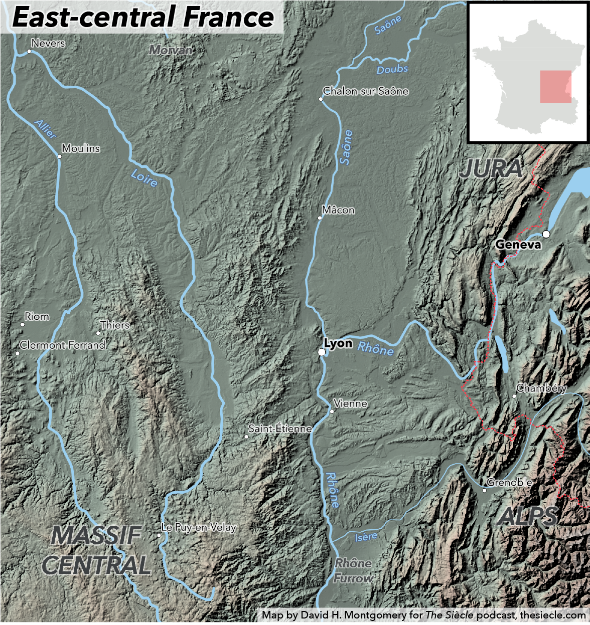
Like Alsace-Lorraine, Lyon and its area in east-central France was strongly Bonapartist; the glove-making town of Grenoble, nestled in a mountain valley southeast of Lyon, was the first city to go over to Napoleon’s cause during the Hundred Days. But the area’s ultra-royalists are also numerous and well-organized.14
From Lyon, we could choose to travel west, up into the mountains of the Massif Central, but well-informed locals would advise us against it. This area is desperately poor in 1815, with few roads and peasants relying on subsistence agriculture; it’s also noted for a “wild character,” including attacks against people as well as property.15 As late as the 1860s, one expert will recommend seeing the region from a hot air balloon, but “only if the aeronaut can remain out of range of a rifle.”16 Instead, we’ll keep going south, down into Provence.
Provence
This mild region runs along the Mediterranean Coast from the Rhône east to the Alps. Today, it’s known for its hilly topography, delicious wines, stunning beaches and warm, dry climate, which together make it beloved to so many English expatriates. And, in fact, tourism was already a phenomenon in the early 19th Century — at that time, “almost exclusively” foreign and especially British.17 And Provence already had several notable wines18, though in 1815 the region’s fields were still dominated by grains, not vines.19

But in the early years of the Bourbon Restoration, if Provence was known for anything, it was perhaps the ultra-royalism of its politics. When Napoleon landed here, he met a decidedly cool reception from towns he had imperiously expected to immediately surrender.20 The region’s royalists included the usual suspects: the old-line nobility, clergy, and traditionalist peasants. But strikingly, many bourgeois and working-class inhabitants of Provence were also supporters of the Bourbons, sentiments fueled in part by the devastating effect the wars of the Revolution and Empire had on the region’s Mediterranean trade.21
This was a region dominated by more relics than just monarchists, if you’ll pardon the injustice of this irresistible pun. France’s Mediterranean coast has been home to cities since before the time of the Romans, whose ruins you can still see in Arles, Nîmes and dozens of other sites. An area around Avignon had belonged to the Catholic Church, not France, until the Revolution, leaving old ruins such as Avignon’s famous bridge and the city’s old papal palace, sacked and used as a barracks by Revolutionary soldiers.
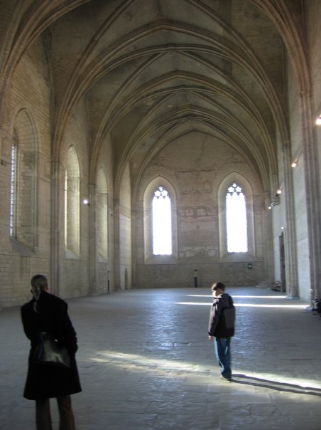
Inside a hall in the Palais des Papes in Avignon, on Feb. 14, 2007. Photo by David H. Montgomery. CC BY-SA 4.0
At the mouth of the Rhône, the great river divides into a vast delta, the Camargue, which was at the time largely a vast swamp “not unlike the lowlands of Louisiana.”22 To the east lies the great bustling port of Marseille, vying with Lyon for the title of France’s Second City23, and the naval port of Toulon. Inland, in the shadow of Mont Sainte-Victoire, is Aix-en-Provence, at the time an “aristocratic town” and several centuries later my home for six months. It’s merely the most significant of a number of towns in the area. Provence had an unusually high rate of urbanization for 1815 France, with southeastern departments showing 50 percent or more of their population living in towns in a country where 10 to 20 percent was a more common figure.24 To the east, the land rises into the Alps everywhere except along the coast — including some parts of modern France, such as Nice, that were still part of the Kingdom of Piedmont-Sardinia at this time.
Across the sea, meanwhile, is the island of Corsica — perhaps the poorest and least urban part of a poor and rural country.25
Languedoc
We will stay in mainland France and head west, into the region known as Languedoc for the common local language, the “Language of Oc” or Occitan — not some mere dialect, but an entirely distinct Romance language then widely spoken across the entire south of France.
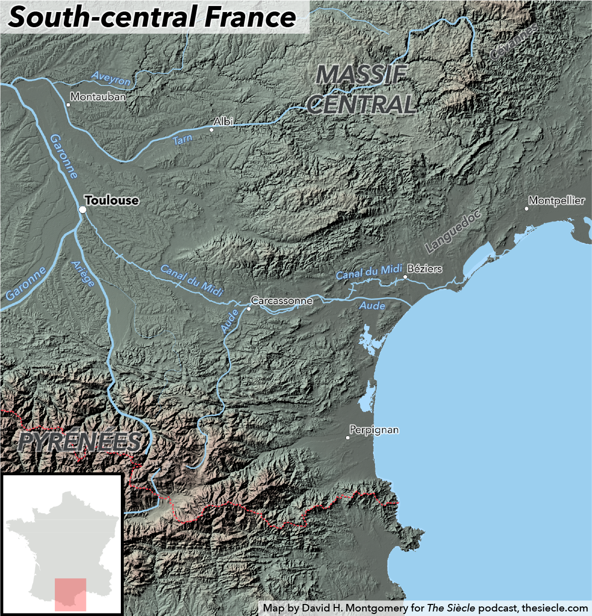
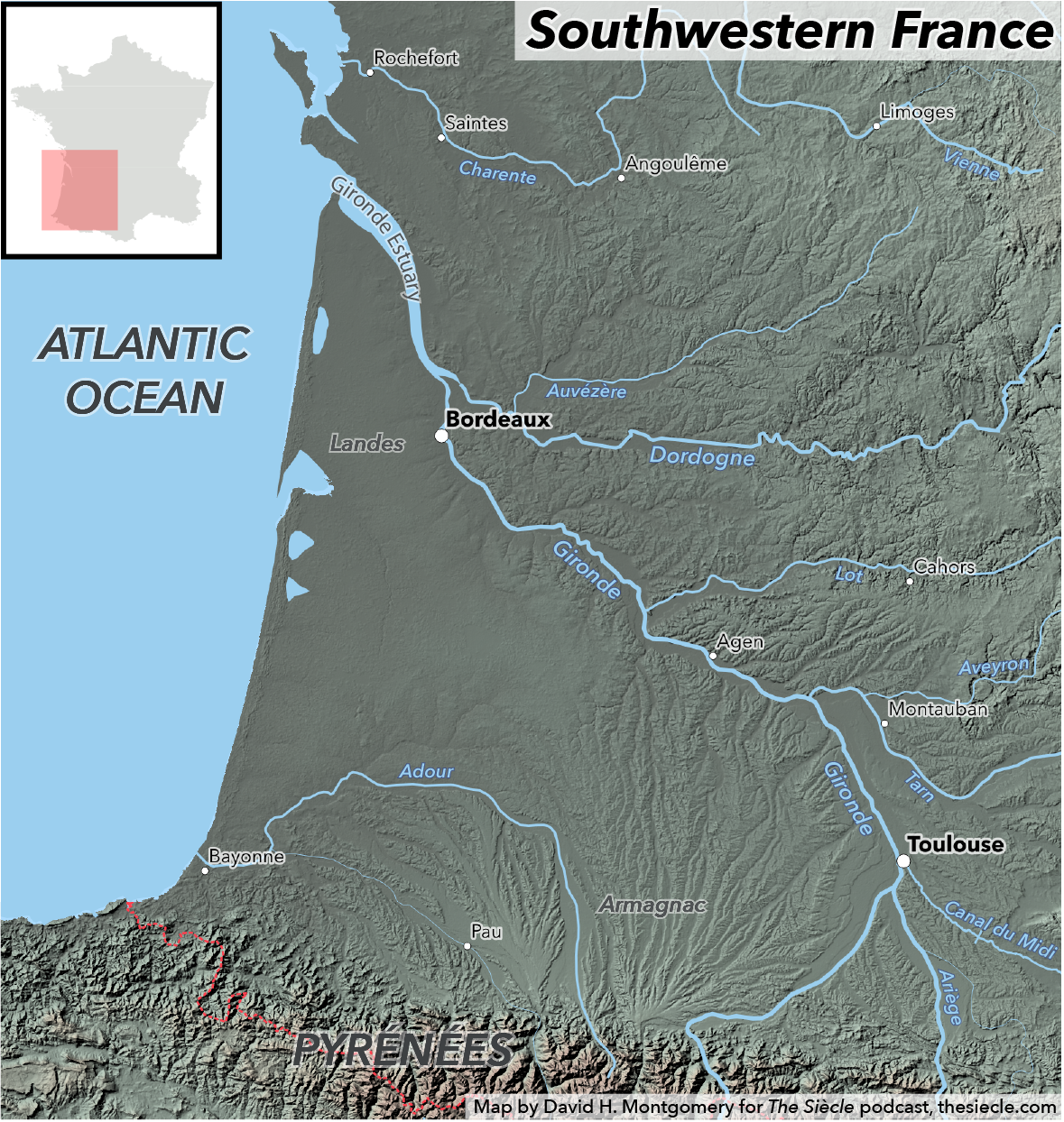
The coastal area of Languedoc, stretching west of the Rhône between the Mediterranean to the south and the Massif Central to the north, is in many ways similar to Provence, except flatter. It shares the vineyards, mild climate and arch-conservatism of France’s southeastern corner — though not its ports, as the coast here is shallow and strewn with sandbars and reefs.26 To the south, the coast reaches the Spanish border and the Pyrenées Mountains. But we’ll keep going west, following a remarkable feat of engineering for 150 miles or 240 kilometers: the Canal du Midi, which rises nearly 200 vertical feet or 60 meters as it cuts across a continental divide. That’d be impressive for 1815 — but the Canal du Midi was completed in 1681. It’s still in use today, though more for pleasure craft than the barges laden with wine, grain, oranges and olive oil that filled the canal during the Restoration.27
Along the way we pass the magnificent medieval walled city of Carcassonne, today best known as the namesake of a popular board game, and descend down into the plains of Aquitaine, which spread over the entire southwest of France. Here, at least, we pick up some good roads, elm-lined avenues emanating into the countyside from the regional center of Toulouse.28 This is still ultra-royalist territory, with Toulouse dominated by great aristocratic estates whose devout nobility clung to feudal customs and sometimes lorded over their peasants as if they were slaves.29
Southwestern France
At Toulouse, we pick up the Garonne River as it flows from the Pyrenées to the Atlantic Ocean, through the Basin of Aquitaine. This is a fertile, densely populated area, though there are exceptions, such as a large region to the southwest that’s a zone of scrubland, swamps and sand, where birdsong is never heard and inhabitants move across the moors on stilts.30 The dominant city of southwestern France is Bordeaux, at the mouth of the Garonne and one of the great cities of France.
Like Marseille, Bordeaux is a port city whose overseas trade suffered greatly from the British blockade during the wars. Its early support for the Bourbons helped get Louis his throne back, but the merchants of Bordeaux are not the same breed of monarchists as we saw around Toulouse and Provence. It is “thoroughly bourgeois” in character, with politics dominated not by conservatism but by moderation and support for free trade.31 In 1814 it backed the Bourbons because they promised peace — but theirs was not an unconditional allegiance.
Western France
Moving north from Bordeaux, we come to the Gate of Poitou, a relatively low-lying area between the Basin of Aquitaine, which we are leaving, and the Paris Basin, which lies ahead. But instead of forging on to Paris, we’ll keep going west, along the Atlantic, through a very notable region: the Vendée. This was the epicenter of royalist resistance to the French Revolution, the scene of bloody atrocities on both sides. It’s a land of thick hedgerows and vast forests, what historian Graham Robb describes as “a muddy labyrinth sunk in a limitless wood.”32 Should we make it through this labyrinth, we’ll reach the seaport of Nantes at the mouth of the Loire. Despite flat terrain and a major river both extending to the northeast, Nantes is isolated by bad transportation: the mouth of the Loire is silting up, and the roads take 48 hours to get to Paris,33 a trip that today takes about five hours by car or two and a half by train.
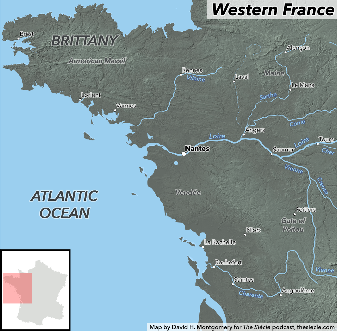
Still, Nantes is positively accessible compared to the region that lies ahead of us: the peninsula of Brittany. The rugged inland areas of Brittany — part of that ancient mountain range, the Armorican Massif — are composed of rocky moors, with poor soil frequently covered by gorse and heath. Still, Brittany is surprisingly densely populated. Victor Hugo would later write of the peninsula’s seeming emptiness, but noted: “if those trees could have been felled at a single blow, as if by a flash of lightning, there would have stood revealed in those shades a swarming mass of men.”34 Like the Vendée, Brittany is a conservative area, where the church and traditional nobility are both powerful institutions.
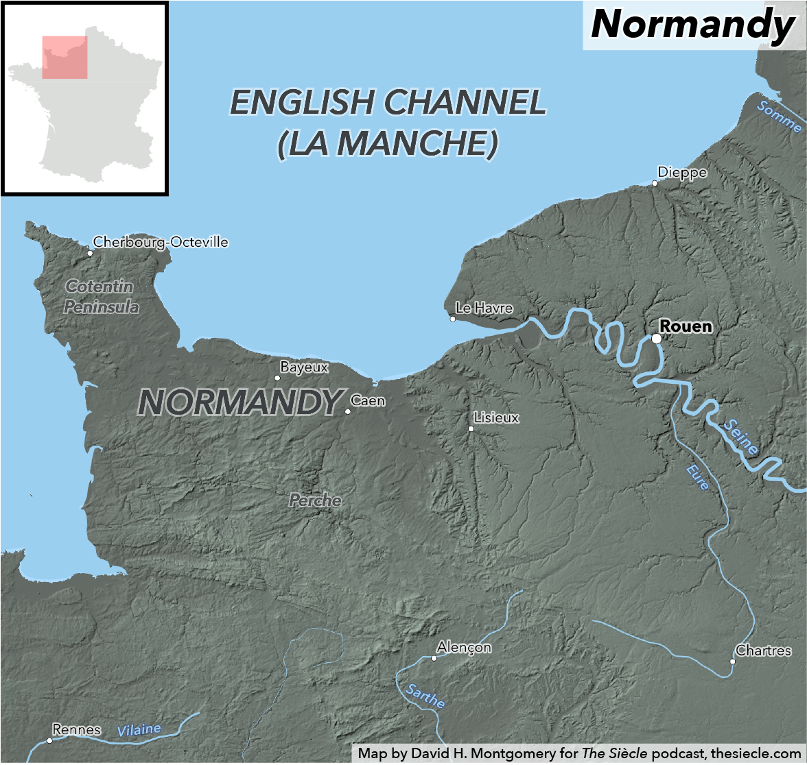
Normandy
Somewhat less isolated is Normandy. Located east of Brittany, it’s much closer to the capital and more accessible, too, taking just 12 hours to get from from Paris to to the Norman city of Rouen instead of the 48 hours it takes to get to Nantes. Normandy is an “active and prosperous region” in 1815, with a much larger percentage of land under cultivation than Brittany and a thriving economy.35
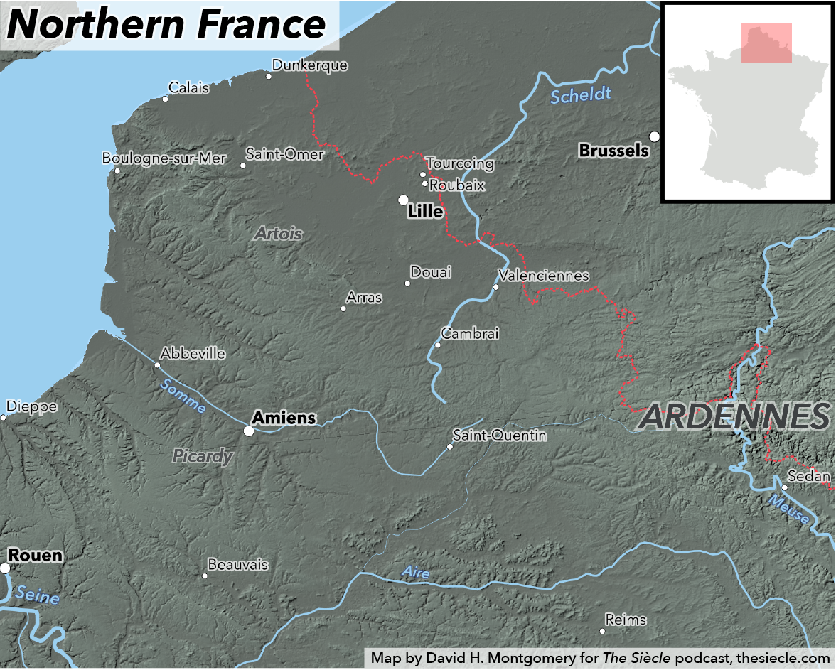
Northern France
Instead of hopping on that fast coach to Paris, though, we’ll continue along the English Channel into northern France, the region located near what is today the Belgian border, though in 1815 Belgium was part of the Kingdom of the Netherlands. This is a prosperous and populated part of the country, and its high population density is all the more remarkable given that it’s largely rural. Northern France is dominated by lots of small plots of land, many of them owned by peasants, but despite owning their own land many of them struggle to feed their families.36 This part of France will very soon become the epicenter of France’s industrial revolution, with factories and mines springing up in the decades to come.
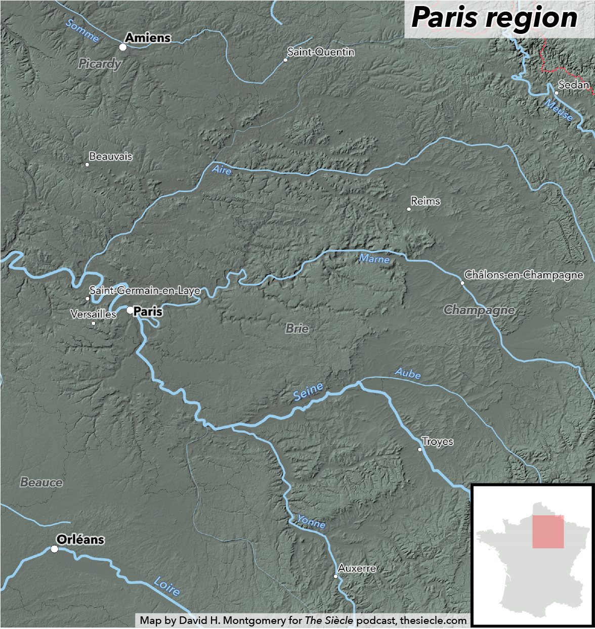
Paris basin
All this brings us to the Paris Basin, that vast network of river valleys and plateaus spreading across the northern third of France, by both its relative fertility and proximity to Paris playing an outsized role in the country’s history. About five million people — one-sixth of the French population — lived in the Paris Basin around this time, not counting the roughly 800,000 living in Paris and its suburbs.37
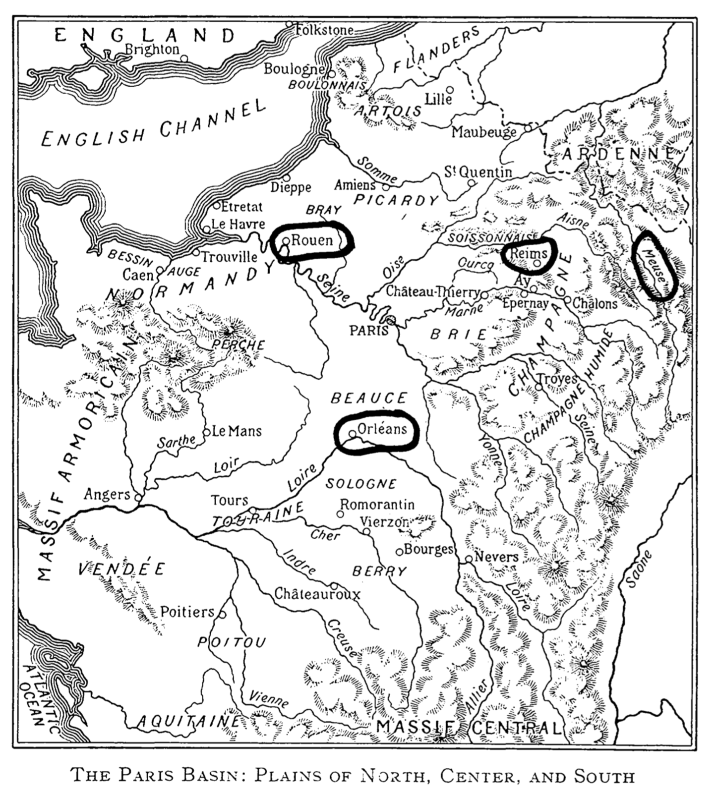
Map from Geography of France by Raoul Blanchard & Millicent Todd, 96. Public domain.
Ironically, the vast region surrounding Paris was one of the least urban in the country — because no city could compete with the metropolis nearby. Instead people lived in towns and villages, growing wheat and grapes and raising livestock, much of it destined for the capital. Some regions, like Valois and Brie, were highly productive and highly commercialized; their permanent population would be supplemented by seasonal migrant workers, such as young girls in the spring to hoe fields in Brie and Beauce, or farmworkers from the north streaming down in the fall to harvest wheat fields.38
Other areas had poorer soil and more traditional ways of living and farming. Some areas south of the Loire River were dominated by forests, marshes and shrubland, plagued by endemic diseases. In the rugged Morvan southeast of Paris, peasants scraped out a meager living from “granitic soil” and lived on “soup and gruel flavored by a little pork.” Even more prosperous parts of the region often saw land broken into tiny peasant-owned plots; even a few acres of good soil could provide enough to feed a family in most years — though harvest failures could prove deadly for peasants living on the edge of survival.39
More famous to foreigners were two prosperous agricultural regions that grew not wheat but grapes: Champagne and Burgundy. These were already well-known as wine-exporting regions, and Champagne wines in particular are poised to become world famous for reasons we’ll discuss in future episodes. The Côte d’Or, or Golden Slope, in Burgundy is similarly in the middle of a two-decade expansion of its vineyards as Louis retakes his throne. Such was the demand for wine — and the relative poverty — that in some regions, wine-making peasants rarely drank any themselves, frugally shipping all their bottles away except for special occasions.40
Culturally, the Paris Basin was marked by “religious indifference,” especially the valleys, which were more accessible to outside ideas. Historians André Jardin and André-Jean Tudesq relate that some areas retained an attachment to religious customs without their spiritual core. One story brings this out clearly: in Yonne, located in between Paris and Morvan to the capital’s southeast, villagers would force the village priest to ring the church bells on St. Philip’s Day and say a special mass — but none of them would bother to attend. Politically, the Paris Basin’s landowners welcomed the return of the Bourbons at first, but would prove troublesome before too long. It’s one of the regions in the Paris Basin that will elect that lifelong liberal revolutionary, the Marquis de Lafayette.41

That finally takes us to Paris, France’s largest city and seat of government. It is here that many of the most dramatic set pieces of the century will play out, here where kings will sit and revolutions form, where fashionable restaurants and museums mingle with impoverished laborers. Unfortunately for you, you’re going to have to wait two weeks for our tour of Paris in 1815. The city is just too big and too important to rush through, and so rather than let this episode swell to gargantuan length, I’ll cut things off now and save Paris for Episode 4.
In the meantime, please visit thesiecle.com/episode3, where you can see maps I’ve made to illustrate this tour around Louis XVIII’s France, as well as full citations for this episode. I’m particularly grateful to André Jardin and André-Jean Tudesq’s book Restoration & Reaction, 1815-1848, whose entire second half is devoted to a survey of France in the years after 1815; their research has formed the backbone of this episode.
If you’re liking the show, I’d invite you to also visit thesiecle.com/support, which has links to several ways you can support the show — everything from spreading the word on Facebook and Twitter to donating a few bucks on Patreon or buying me French history books from my Amazon wishlist that I can use to research future episodes. Thank you so much for listening and any support you are able to give — producing this podcast takes a lot of time and a surprising amount of money, and I’d love to be able to devote more time to researching, writing, recording and editing episodes.
If you have any questions, please shoot me a message on Twitter at @thesiecle, or by email at david@thesiecle.com. See you in two weeks for Episode 4: The Paradox of Paris.
-
André Jardin and André-Jean Tudesq, Restoration & Reaction, 1815-1848, translated by Elborg Forster (Cambridge: Cambridge University Press, 1983), 28. ↩
-
B.R. Mitchell, ed., European Historical Statistics: 1750-1975. 2nd Rev. Ed. (London: The MacMillan Press Ltd, 1981), 30. ↩
-
Jardin & Tudesq, Restoration & Reaction, 366-7. Mitchell, European Historican Statistics, 88. Institut national de la statistique et des études économniques. Note that modern-day Paris is larger geographically than the Paris of 1814. ↩
-
For more, see Wikipedia’s article about German mediatization. ↩
-
Raoul Blanchard and Millicent Todd, Geography of France. (Chicago: Rand McNally & Company, 1919), 84. Graham Robb, The Discovery of France: A Historical Geography from the Revolution to the First World War (New York: W. W. Norton & Company, 2007), 15. ↩
-
Blanchard & Todd, Geography of France, 21. ↩
-
Jardin & Tudesq, Restoration & Reaction, 305. ↩
-
Jardin & Tudesq, Restoration & Reaction, 306. ↩
-
Jardin & Tudesq, Restoration & Reaction, 316. ↩
-
Blanchard & Todd, 44-7, 138-9. Jardin & Tudesq, 304-28. ↩
-
Robb, The Discovery of France, 61. David H. Montgomery, “Obscenities and oaths: French languages before the Revolution,” dhmontgomery.com, Feb. 27, 2018. ↩
-
Jardin & Tudesq, Restoration & Reaction, 275-6. ↩
-
Jardin & Tudesq, Restoration & Reaction, 282-5. ↩
-
Jardin & Tudesq, Restoration & Reaction, 288-90. ↩
-
Jardin & Tudesq, Restoration & Reaction, 298-9. ↩
-
Robb, The Discovery of France, 5. ↩
-
Robb, The Discovery of France, 277, 286-7. ↩
-
John MacGregor, Commercial Statistics: A Digest of the Productive Resources, Commercial Legislation, Customs Tariffs […] of All Nations., Vol. 1 (London: Charles Knight & Co., Ludgate Street, 1844), 370-3. ↩
-
Jardin & Tudesq, Restoration & Reaction, 242-4 ↩
-
Paul Britten Austin, 1815: The Return of Napoleon (Barnsley: Frontline Books, 2002), 23-37. ↩
-
Jardin & Tudesq, Restoration & Reaction, 234-7. ↩
-
Blanchard & Todd, Geography of France, 34. ↩
-
Mitchell, European Historical Statistics, 86-88. Jardin & Tudesq, Restoration & Reaction, 241, 271. ↩
-
Thomas Beck, French Legislators 1800-1834: A Study in Quantitative History (Berkeley: University of California Press, 1974), 154-7. ↩
-
A full 94 percent of property in Corsica paid less than 20 francs in taxes, the smallest category. There were perhaps only 40 people on the whole island who met the wealth requirements to vote in the Restoration’s limited-franchise elections. McPhee, A Social History of France: 1789-1914, 110, 148. ↩
-
Blanchard & Todd, Geography of France, 32-3. ↩
-
Robb, The Discovery of France, 233. ↩
-
Robb, The Discovery of France, 225. ↩
-
Jardin & Tudesq, Restoration & Reaction, 235. ↩
-
Robb, The Discovery of France, 9-10. This desolate region is called the Landes; later in the 19th Century it would be converted from a moor to a pine forest. ↩
-
Jardin & Tudesq, Restoration & Reaction, 260, 265-70. ↩
-
Robb, The Discovery of France, 15. ↩
-
Jardin & Tudesq, Restoration & Reaction, 217. ↩
-
Quoted in Robb, The Discovery of France, 14. ↩
-
Jardin & Tudesq, Restoration & Reaction, 217-8 ↩
-
Jardin & Tudesq, Restoration & Reaction, 229-30. ↩
-
Beck, French Legislators, 154-7, for population figures. Jardin & Tudesq, Restoration & Reaction, 362, for definition of the region. ↩
-
Robb, The Discovery of France, 146-7. Jardin & Tudesq, Restoration & Reaction, 346-9. ↩
-
Jardin & Tudesq, Restoration & Reaction, 346-55. ↩
-
Jardin & Tudesq, Restoration & Reaction, 355-7. ↩
-
Jardin & Tudesq, Restoration & Reaction, 360-3. ↩